

FREQUENTLY ASKED QUESTIONS

General
-
Feel free to contact the SCDOT Project Director, Kit Scott, if you have any questions or concerns. She can be reached by phone at 803-737-1138 or email at info@526lowcountrycorridor.com. You can also visit us at the Project Office at 5605A Rivers Avenue, North Charleston in Gas Lite Square. Office hours are Monday - Friday, 10 am - 5 pm and by appointment any time by calling/texting 843-258-1135.
-
The Federal Highway Administration (FHWA) approved the Finding of No Significant Impact (FONSI) in August 2024, meaning based on the information provided during the environmental process, FHWA found that there would be no significant environmental impacts. This documentation is available here.
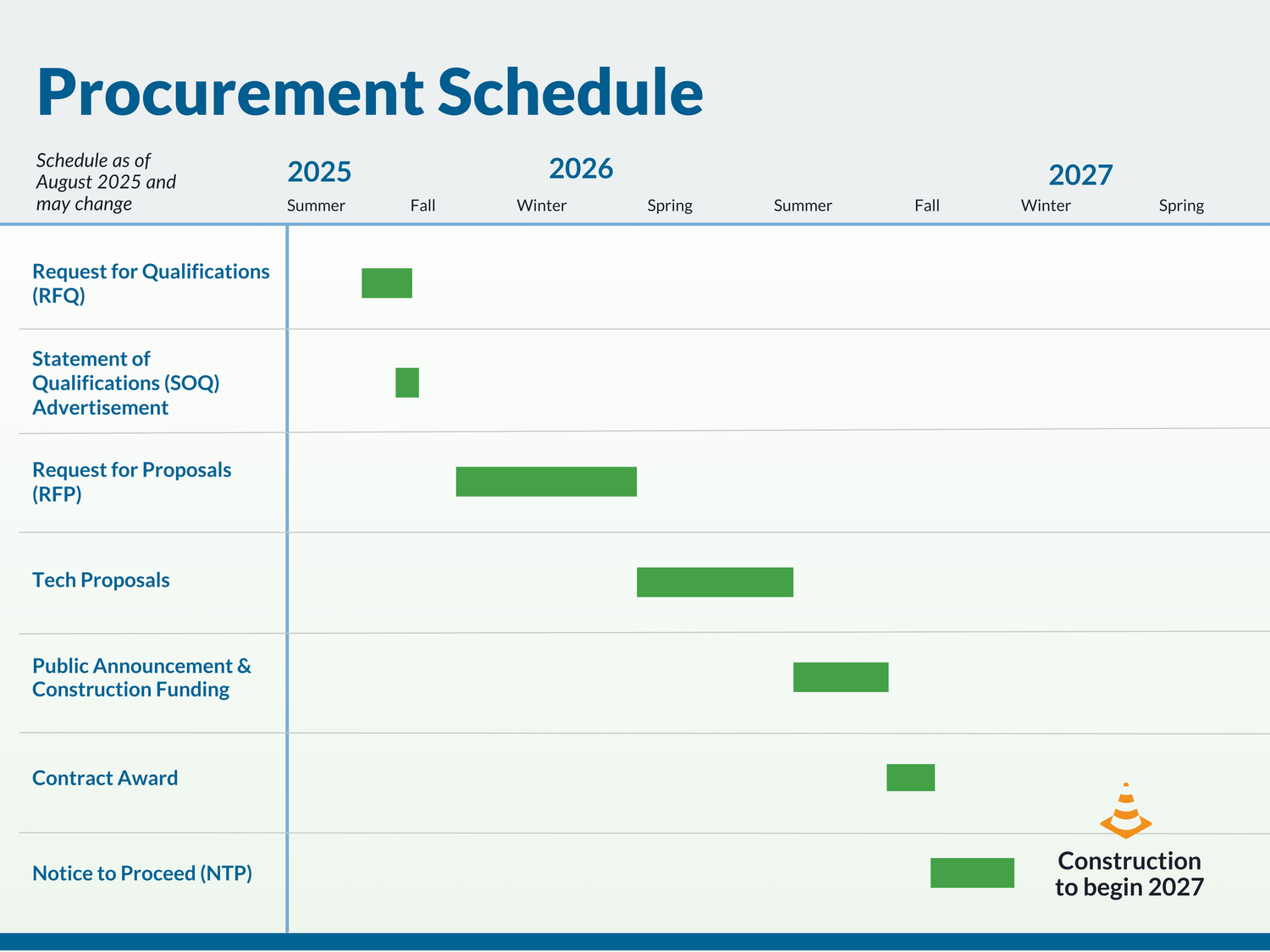
The project is currently being prepared to begin the Design-Build process, an alternative project delivery process in which a single contract is awarded to provide both design and construction services. The Design-Build team selection process began in Fall 2025. Construction of the Selected Alternative is anticipated to start in 2027 and last approximately three and a half years. Please see the anticipated procurement schedule to get construction started below.
SCDOT, in cooperation with FHWA, is increasingly using the Design-Build process in an effort to expedite project delivery. Learn more here.

Project Details
-
The Selected Alternative retains the existing operations at Long Point Road and Belle Hall Parkway. SCDOT updated the original plans for this intersection based on input from the local community followed by further engineering analysis, with the goal of improving this interchange to best serve all users. SCDOT will continue to monitor the safety of this intersection.
-
SCDOT is responsible for stormwater runoff on all state-maintained roads and bridges and the project is designed to collect stormwater in accordance with SCDOT’s Stormwater Quality Design Manual. SCDOT works to minimize impacts to the environment and communities as the designs are refined. While SCDOT first works to avoid and minimize impacts to wetlands, any anticipated, unavoidable impacts would require a permit from the U.S. Army Corps of Engineers in addition to mitigation to offset those unavoidable impacts. The results of all environmental studies, including environmental impacts, are published within the Environmental Assessment (EA). The EA was made available to the public for review during the public hearing and corresponding comment period. The final EA and Finding of No Significant Impact (FONSI) is also available online here.
-
A shared-use path will be incorporated within the project limits of the design, where possible, and would provide connectivity with potential future bicycle and pedestrian facilities and I-526 widening. Where logical connections to existing facilities such as sidewalks or bike lanes exist, SCDOT will construct the planned improvements within the project area. If there are no existing connections or a logical location to safely end the bicycle, pedestrian, or transit facilities within the project area, then SCDOT will ensure drainage, shoulder, and roadway design could accommodate these additional features in the future. This strategy would allow future projects to easily make this connection within the existing roadway footprint without major modifications. The preliminary plans include a multi-use path along the east side of Long Point Road within the project limits, and existing sidewalk on Long Point Road would be replaced as part of the project within the project limits. Additionally, a multi-use path will replace the sidewalk along the south side of Wando Park Boulevard within the project limits.
-
The Preferred Alternative is designed to improve traffic operations and reduce conflicts between port-related and local traffic. The new ramps included in this design would provide trucks destined to, and coming from, the Wando Welch Terminal with a more direct connection to I-526 and the ability to avoid local traffic on Long Point Road. With the Preferred Alternative, the number of trucks on Long Point Road is estimated to decrease from 70% to 15%, while traffic on the new ramps is anticipated to be 90% trucks.

Noise
-
A traffic noise study was conducted as part of the Environmental Assessment. A total of four noise barrier locations were identified as feasible and reasonable for the Selected Alternative. This includes proposed noise walls north of I-526 and west of Long Point Road between the Wando River bridge and Belle Hall Parkway, south of I-526 between the Wando River bridge and Ridge Road, south of I-526 and east of Long Point Road between Lone Tree Drive and the bridge at Hobcaw Creek, and north of I-526 and east of Long Point Road between Long Point Road and the bridge at Hobcaw Creek. A map of the noise walls can be found online at here.
Property owners, residents, and businesses that would benefit from the noise walls were contacted and allowed to vote on whether they wanted the noise walls constructed or not. The results of this voting process affirmed the desire for all four noise walls. The complete noise study can be found here.

Right-of-Way
-
When SCDOT builds or improves roads and bridges, we often have to acquire property, known as right-of-way, or ROW. We have uniform practices for conducting property acquisitions, providing relocation assistance, and preparing appraisals. We follow the Uniform Relocation Assistance & Real Property Acquisitions Policies Act of 1970, which protects property owners’ rights and ensures that everyone is treated fairly and equitably during property acquisitions. For more information on the right-of-way process, visit the SCDOT website by clicking here. If you have specific questions about the ROW process or relocation benefits, please give us a call at 843-258-1135.
-
Based on preliminary design, the Selected Alternative would not require any residential relocations; however, it would require the potential relocation of 10 buildings and two outbuildings, including a cell phone tower. SCDOT is developing the Request for Proposals for the project to encourage proposed designs that will reduce the number of relocations. As SCDOT advances through the procurement process, the design will become more detailed as it is further refined and finalized.
For details associated with the ROW analysis, see Section 4.5 of the FONSI here.
-
SCDOT has begun early right-of-way acquisition for tracts that are anticipated to be relocated. The selected Design-Build contractor will complete right-of-way acquisition based on the final design of the project.
-
SCDOT follows the Uniform Relocation Assistance and Real Property Acquisition Policies Act of 1970, as amended. Compensation and relocation assistance will be provided in accordance with federal requirements. For more information on the right-of-way process, visit the SCDOT website: www.scdot.org/business/pdf/rightofway/Relocation.pdf, view an informational video on the right-of-way process on our website here, or email us to connect with a right-of-way agent.
Additional Right-of-Way Resources
Learn more about SCDOT’s right-of-way acquisition process by watching the videos or reading the questions above.